Skip to header Skip to main navigation Skip to main content Skip to footer

Search form

Home
Questa New Mexico

Main navigation

  • Home

Rio Grande

Breadcrumb

  • Home
  • Rio Grande

Where Two Wild Rivers Meet: The Confluence Below Questa
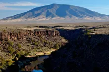
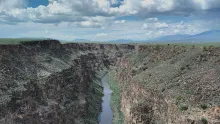
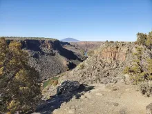
The Rio Grande Gorge in the Wild Rivers Recreation Area near Questa, with Ute Mountain rising beyond the canyon rim.

Did you know that the Rio Grande Gorge near Questa began, in a sense, with the Red River? Scientists with the Bureau of Land Management explain that about 400,000 years ago a closed basin in Colorado's San Luis Valley, holding a lake with no outlet, grew wetter and overflowed to the south. That water drained into the Red River, and as its volume increased it cut down through volcanic rock to form the modern Rio Grande Gorge.
  • Read more about Where Two Wild Rivers Meet: The Confluence Below Questa

Bighorn Sheep and Fall Light in the Gorge: A Saturday at Wild Rivers

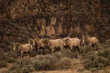
A photograph of a band of Rocky Mountain bighorn sheep rams standing in sagebrush on the plateau above the basalt cliffs of the Rio Grande Gorge in the Rio Grande del Norte National Monument.

Saturday, October 31, 2026

There is no better place to spend a crisp fall Saturday near Questa than the rim of the Rio Grande Gorge at the Wild Rivers Recreation Area, in the heart of the Rio Grande del Norte National Monument. This morning starts cloudy and cool in the village, in the low 40s, before skies turn partly cloudy and the afternoon high reaches the mid-50s — fine weather for a slow drive out to the overlooks, a rim walk, and some patient wildlife watching.

  • Read more about Bighorn Sheep and Fall Light in the Gorge: A Saturday at Wild Rivers

Rio Grande Running High at Wild Rivers: A Careful Fishing Report for Questa

A photograph of the Rio Grande winding through the deep volcanic gorge at the Wild Rivers Recreation Area, with Ute Mountain in the distance.

Thursday, October 29, 2026

The Rio Grande below Questa is a different river this week. After upstream precipitation, the river through the Wild Rivers Recreation Area is running high and fast, and a River Flood Advisory is in effect for the area until Friday at noon. This is not a week for casual wading in the main channel. It is a week for watching the gorge from the rim, fishing carefully from the bank where the water softens, and respecting how quickly this canyon river can change.

  • Read more about Rio Grande Running High at Wild Rivers: A Careful Fishing Report for Questa

Servilleta Basalt: The Black Rock That Built the Rio Grande Gorge

A photograph of the dark Servilleta Basalt cliffs of the Rio Grande Gorge near Questa, New Mexico.

West of Questa, the land opens into the broad Taos Plateau, and then, almost without warning, it drops away. At the Wild Rivers Recreation Area, where the Red River meets the Rio Grande, you can stand at the rim and look into a gorge the Bureau of Land Management describes as up to 800 feet deep, carved through layers of volcanic basalt flows and ash interbedded with sand and gravel. The dark rock in those walls has a name every local rockhound should know: Servilleta Basalt.

  • Read more about Servilleta Basalt: The Black Rock That Built the Rio Grande Gorge

From Sheep Herds to Cattle: Ranching and Farming in the Questa Valley

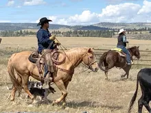
A photograph of Manuel and Libby Lucero gathering cattle near San Antonio Mountain, New Mexico.

Did you know Questa began as a village of sheep farmers? The first Questa-area settlers traveled to the Rio Colorado country on the Kiowa Trail between 1805 and 1818, driving their sheep with them, and by 1835 families were coming up from Taos to farm and graze sheep here through the summers. When the permanent village of San Antonio del Rio Colorado was founded in 1842, flocks were at the heart of it, and in the mid-1800s a wall built around the plaza offered the fledgling settlement of sheep farmers and traders a stability its people had not enjoyed before.

  • Read more about From Sheep Herds to Cattle: Ranching and Farming in the Questa Valley

Questa's Hydrogen Project in Depth: Storage and Jobs Promised, Water and a 2009 Easement Contested

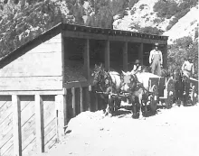
A 1926 photograph of a horse-drawn wagon loaded with ore at the Questa molybdenum mine, the former mine land where a green hydrogen facility is now proposed.

Wednesday, October 28, 2026

  • Read more about Questa's Hydrogen Project in Depth: Storage and Jobs Promised, Water and a 2009 Easement Contested

Questa's Acequias: Water Shared for Generations

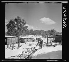
Arthur Rothstein's 1936 photograph of a man digging an irrigation ditch in Taos, New Mexico.

In Questa, water is life, and for generations that water has arrived the communal way: through acequias. These irrigation ditches carry water from the Red River and Cabresto Creek to the fields and gardens of the village, shared among neighbors under a tradition far older than the town's current name.

  • Read more about Questa's Acequias: Water Shared for Generations

Watchmen on Sentinel Peak and Flag Mountain Guarded Early Questa

Flag Mountain rising above Questa, New Mexico, photographed from New Mexico State Road 522 just north of the village.

Look up from Questa and you will see two high sentinels of stone: Sentinel Peak and Flag Mountain. Their names are not accidents of poetry. They remember a time when the survival of a small settlement depended on watchful eyes posted high above it.

The settlement was founded as Rio Colorado in 1842, after a grant to 35 families. Thirty-five families is a village, but a small one, and those families were planting their lives in an exposed place. Everything they built, planted, and raised depended on their ability to see trouble coming in time to respond.

  • Read more about Watchmen on Sentinel Peak and Flag Mountain Guarded Early Questa
Subscribe to Rio Grande

Copyright © 2026 Rocky Mountain Madman LLC - All rights reserved

Developed and Designed by Rocky Mountain Madman LLC