Skip to header Skip to main navigation Skip to main content Skip to footer

Search form

Home
Questa New Mexico

Main navigation

  • Home

Carson National Forest

Breadcrumb

  • Home
  • Carson National Forest

Cabresto Canyon by Forest Road 134: Questa's Backroad to a High Mountain Lake
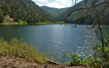
A photograph of Cabresto Lake below forested peaks in the Carson National Forest northeast of Questa, New Mexico.

East of Questa, one of the village's favorite backroads leaves the highway and climbs into the Carson National Forest. Cabresto Canyon follows Cabresto Creek up through pine and aspen, and the drive ends, for motorized travel, at a small mountain lake tucked under high peaks. It is an easy road to describe and a rewarding one to drive slowly, with the creek, the canyon walls, and the changing light doing most of the work.
  • Read more about Cabresto Canyon by Forest Road 134: Questa's Backroad to a High Mountain Lake

NM 38 East from Questa: Over Bobcat Pass on the Enchanted Circle

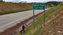
The Bobcat Pass summit sign on NM 38 reading Elev 9820, photographed for a CycleBlaze cycling journal.

Every great mountain drive has a beginning, and for travelers heading east from Questa, it begins on NM 38. The highway was named by 1912 for the Questa-to-Eagle Nest route, a road tying the village to the Moreno Valley. More than a century later, it remains the way east: out of Questa, into the canyon, and up toward the high country.

  • Read more about NM 38 East from Questa: Over Bobcat Pass on the Enchanted Circle
Subscribe to Carson National Forest

Copyright © 2026 Rocky Mountain Madman LLC - All rights reserved

Developed and Designed by Rocky Mountain Madman LLC