Tuesday, November 3, 2026
If you are driving around Questa today, the weather is on your side. It was clear and cold early this morning, around 34 degrees, with sunny skies ahead and a high near 52 degrees. There are no weather alerts in effect for Questa or Taos County, sunrise was at 6:28 AM and sunset comes at 5:03 PM, so plan mountain driving with that early darkness in mind, especially on shaded curves where a cold morning can leave the pavement slick long after the sun is up.
The local routes that tie the valley together are NM-522 between Taos and Questa and on to the Colorado line, NM-38 over the Enchanted Circle toward Red River and Eagle Nest, and US-64 between Taos and Eagle Nest. The sources checked this morning did not list a closure on those Questa-area stretches, but conditions in northern New Mexico have been changing quickly after the weekend rain, so check NMRoads at nmroads.com before you leave for the official, mile-by-mile word on work zones, crashes, or any new restriction.
The one New Mexico highway story still unfolding today is farther west, around Chama. A Flood Warning for north central Rio Arriba County remained in effect until noon today for flooding of the Rio Chama between the Colorado border and El Vado Reservoir, with a few roads in Chama still closed due to flooding. US Highway 64 and US Highway 84 were impacted there earlier in this flood event, and on November 2 the governor asked for a federal major disaster declaration for the October 22 to 30 flooding in northern New Mexico. That Chama stretch of US-64 is a different segment from the Taos to Eagle Nest drive, but anyone crossing the north on US-64 from the west should expect the Chama area to still be recovering and verify its status before setting out.
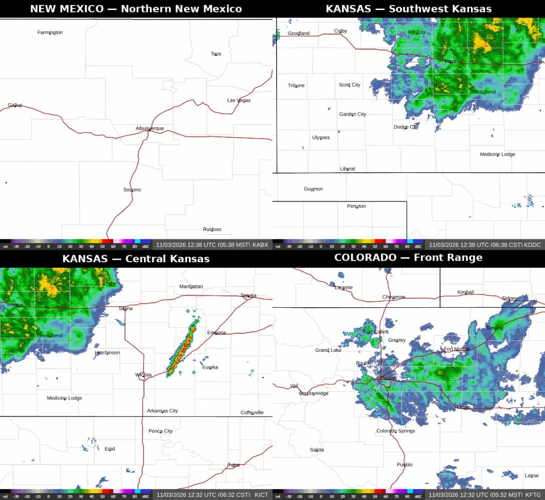
For drive-ins, the shared morning radar tells the split story clearly. Northern New Mexico and the Enchanted Circle are clear, while heavy rain is crossing northern Kansas on I-70 through Hays and Great Bend and reaching toward Dodge City and US-56, with heavy rain also over Great Bend and Salina in central Kansas and a line of storms east of Wichita. Rain is also crossing the Colorado Front Range on I-25 through Denver and Fort Morgan. Kansas drivers heading this way also face a very windy Tuesday, with northwest winds gusting into the 40s around Dodge City and only a slight chance of early showers before skies turn partly sunny.
The practical plan is simple. Enjoy a sunny, straightforward drive on NM-522, NM-38, and the Enchanted Circle today, give yourself daylight for the high country, and build in extra time if your route starts in Kansas or down the Colorado Front Range, where wet pavement and strong crosswinds are the delays to expect. Re-check NMRoads for New Mexico, COtrip for Colorado, and the Kansas traveler information before the return trip as well, because flood recovery west near Chama and the fast-moving rain to the north and east can change a route picture in a few hours.